
River Chvojnice - Czech republic
20 km
| Basic information about river river sections Kilometrage Localites | Services Article Fotogallery Videogallery | Discussion Water stages |
River description:
The river springs in south of Velká Bíteš town. Its flow is orientated to the southern direction , and near to Senoradský mlýn (mill) at Ketkovice it mouths to Oslava-river from the left side.
The river-basin makes 64 lm2, the length of flow is 12 kms.
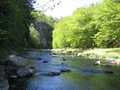
From the above mentioned paragraph it follows that Chvojnice is a very small streamlet. It flows through afforested valley, its slope is quite great, there are many rapids on many places.
The navigation is therefore quite difficult , owing to many small tree-bridges and laying trees across the river. A small irrigation basin there was built on streamlet in the past, so the flow over the basin lost its importance for watermen. Water-index is missing on Chvojnice, the navigation is managed with the water quantity let out the dam. The average slope of this section is 12 promile, the difficulty WW II. This section can be driven within 3-5 hours.
The navigation is slowed-down with low tree-bridges and laying trees in river-bed, the boats are to be carried over many times.
First aid:
In health centre in Oslavy


