
River Chomutovka - Czech republic
The river sources northern of the community Hora sv.Šebestiána in Ore Mountains.
45 km
| Basic information about river river sections Kilometrage Localites | Services Article Fotogallery Videogallery | Discussion Water stages |
River description:
Ohře river - basin – mouths to Ohře river.
The river takes its sources in northern direction of the community Hora sv.Šebestiána in Ore Mountains at the altitude of 835 m of sea level and flows in the southeastern direction up to its mouth to Ohře-river in Postoloprty. The river-basin makes a surface of 160 km2. The section up to the town of Chomutov is flowing through nice mountain valley in a narrow stony bed. In Chomutov thne rver is covered and it is impossible to continue through. The further navigation is possible from Údlice , where the river flows through flat valley in a clayish bed and along meadows nearby. The weirs on the lower flow are not navigable.
In its upper flow the river is navigable during spring thaws and after strong rains only, eventually after the water springs are let out from a dam of Křimovský brook. The decisive water-index is 70 cm, placed on Křimovský brook ,shortly before its mouth to Chomutovka.
The section from Údlice is less difficult for a water and it is possible to drive in an open boat as well. The navigation is not so interesting.
Accommodation:
We find a camping place near to the place of Druhý Mlýn on its upper flow, the accommodation nearby Třetí Mlýn or in Chomutov.
Food-supply:
It is available in Chomutov, Údlice and Postoloprty.
First aid:
It is available in health centres in Chomutov and Postoloprty.
Places of interest:
- Chomutov: early Gothic church of 13th century, Renaissance town hall with a museum, former Jesuit´s monastery
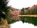
- Kamencové lake: near to Chomutov, the recreation resort, former mining,.now inundated.
- Postoloprty: Details see at Ohře-river.


