
River Chrudimka - Czech republic
The river sources in Žďárské vrchy, near to the community of Svratouch.
104 km
| Basic information about river river sections Kilometrage Localites | Services Article Fotogallery Videogallery | Discussion Water stages |
River description:
The river basin of upper Elbe mouths to Elbe.
The river springs in northwest of the community of Svratouch in Žďárské vrchy (Žďárské Highlands) in the altitude of 700 of sea level. It flows through Železné hory and via Chrudimská- plain to Pardubice- basin, where mouths to Elbe-river in Pardubice.
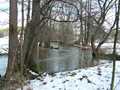
The river flows first to northwest, near to community of Seč turns violently to the east, and on northern slopes of Železné hory bends to the north to Pardubice. The river-basin makes
873 km2.. The countryside along the river is changing several times. From the community of Hamry flows with quick stream through narrow river-bed between meadows and forests, where some sections are overgrown. The best part remained, unfortunately, under the water-level of Seč-Dam. Further, along the levelled pier, the river follows through nice but not great slope to the other airy basin near to Křižanovice. The river bed is clear here and the navigation is safe. The further section is – up to the other basin in Svídnice – dry.
Otherwise, there is a difficult, bouldery section, named Peklo (Hell). Lower, under Svídnice,the number of weirs is decreasing, the river-bed is wider , and the river , in general is not interesting, from here begins a plain. The weirs on the upper flow are damaged, on lower flow are not navigable.
Chrudimka river has interesting, at great water-level navigable tributary – Novohradka-river.
As the river is divided into various sections, so different is the navigability and water-level.
For the section from Hlinsko or Trhová Kamenice it is sufficient moderately better situation
after strong rains or in spring. At Seč-Dam ( on weekends, sometimes on Saturdays in the morning) the power station is working, let the water flowing ( 9m3/sec.) what is sufficient for navigation to Mezisvětí. From Křižanovice-Dam is mostly dry, however. Provided the water
would be let flow (in extraordinary cases) so it is better to investigate the section in advance,
as there could be laying the trees in river bed, and there are also the fences of a park , and so it is extremely difficult to carry over the boats. As to the section from Svídnice – the water index in Slatiňany is presented 110 cm, for the navigation from Chrudim it is a minimum
40 cm for navigation. The navigation on upper part is not difficult. the section from Trhová Kamenice is possible to drive with an open boat,too. The navigation speed corresponds to those of 5 kms/hour. The section from Seč is quicker as there are less obstacles here.
The descend through Peklo (hell) valley is for the whole day, the investigation is necessary!
From Svídnice there are no problems more.
Accommodation:
The camping places are to be found in Seč and in Paseky, the accommodation could be reserved along all places along the river.
Food-supply:
It is available in Hlinsko, Trhová Kamenice, Horní Bradlo, Seč, Bojanov, Svídnice, Slatiňany, Chrudim and Pardubice.
First aid:
It is available at health centres in Hlinsko, Trhová Kamenice, Seč, Slatiňany, Chrudim and Pardubice.
Places of interest:
- Hlinsko: originally Gothic, now Baroque church, Baroque town hall of 18th century, museum.
- Veselý Kopec: skansen (reservation) of people´s buildings.
- Trhová Kamenice: carpentered people´s buildings , Baroque church.
- Seč: ruins of castle Oheb of 14th century, the rests of castle Vildštejn, Renaissance castle.
- Slatiňany: renaissance castle, museum, castle park.
- Chrudim: town´s monumental zone, original Gothic houses and churches, Baroque town hall.
- Pardubice: see Elbe


