
River Revúca - Czech republic
This river sources in south part of Velká Fatra Mountains.
26 km
| Basic information about river river sections Kilometrage Localites | Services Article Fotogallery Videogallery | Discussion Water stages |
River description:
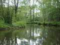
The river sources in south part of Velká Fatra Mountains. From here, it flows at first in east direction, from Liptovská Osada continues in north direction up to its mouth into Váh-river in the town of Ružomberok. Its river basin takes 265 km², the length of navigable section makes 26 kms. The river, especially in its upper part, has quite remarkable slope and narrow stony and bouldery river bed. Its slope is getting lower consequently, and river bed getting wider. So, from the mouth of Trlenská small river, there is necessary to descend Revúca-river just at moderately higher water level. Later, the stream becomes moderate and rapids, which are often appearing in its upper section, are disappearing.
However, in suburbs of the town of Ružomberok, the river is hardly polluted and it is necessary to finish in time your navigation. In its upper section, the river is suitable for watermen with covered vessels only. On the other hand, the low section is possible to descend with open boats, too.
Accommodation:
It is available in the town of Ružomberok.
Food supply:
It is available in Ružomberok.
First aid:
It iws available in Ružomberok.
Places of interest:
- Liptovská Osada - community with people´s wooden houses and a church.


