
Region of Ústí - Czech republic
REGION OF ÚSTÍ
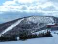
Its border is formed from prevailing part by mountain range of Krušné hory (Ore Mountains) with the biggest peak of Klínonec (1244 m).
| Basic information about region Localities Subjects | Articles Photogallery Videogallery | Discussion |
Localities
Střekov Sluice
Dams
Ústí nad Labem district
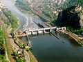
Střekov Sluice
This water work is situated on Labe (Elbe) river and was built within 1924 - 1936, nearby  Střekov Castle, according to plans of Frantisek Vahal. The work would serve to the fact that water energy for production of electric stream would be used in better way. At that time period, this sluice belonged to most modern constructions in former Czechoslovakia. Till now, it is fully in function, and the building is declared as technical monument.
A weir, 111 metres long, is to be placed here. It is divided, by means of three pillars, into four fields, 24 metres long. The pillars are 5 metres long, and boarded with granite freestones in its lower part. The weir inflates water level of the river in distance of 19,8 kms. Maximal height difference between upper and lower water level is 9,75 m.
The sluice is equipped with passage for fish, and serves as foot-bridge for foot passengers. However, fish-passage showed to be as out of order, so the sluice happened to be as final station for moving fish, as for salmons, for instance.

Text: Václav Zamba
Photo: google


Regions / Europe / Czech republic

Guide:
Important Information:
![]() Information and warnings on travelling abroad is to be found HERE.
Information and warnings on travelling abroad is to be found HERE.
Mobile application:

![]()
![]()


