
SK, Povazska Bystrica: Tourist Trip to the Klapy – VIDEO

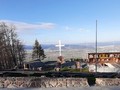
Povazska Bystrica was our point of start, to be more concrete its district of Povazske Podhradi. As we were there on beautiful, sunny day we were bursting with expectation. Before the climb, we enjoyed an amazing mountain range rising above Nosice water reservoir. It was split into two parts – the Small and the Great Carpathians. The massif is a part of a klippe belt. The mountain range is known for Pulsatilla slavica, a plant endemic to this region, and other rare flora and fauna.

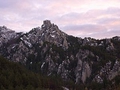
Our trip starts out at Povazsky Chateau which makes typical silhouette of the Povazi region. Getting to the castle is at your own risk. Under its steep klippe on the right riverbank of the Vah (by the chateau), a yellow nature trail commences. Half an hour of walking later you reach Lopatina direction board. There you can continue by going down the blue nature trail. Soon you will lay your eyes on beautiful meadows near Uhry mountain village and Klapov mountain range. Go on till you reach the klippe which goes by the same name. Here you hike along steep terrain and follow the yellow nature trail. Then you reach the summit.
")
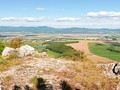
The reward after strenous climb is the vista over the surroundings from 654 meters of altitude. You can see water dam, local villages and towns, Povazska Bystrica, Sulovske rocks, Manin, Vrsatecka klippe, Strazov and even Rozsutec. Then you can descend along the same way back down. Alternatively you can follow the yellow trail to Udica village.
")
")
")
A trip to Klapy can start out from Udica village. It is the shortest yet the steepest marked trail. Or you can start out from Uhry gardeners' settlement which is situated close to the main road between Bystrica and Puchov.
")
Next to amazing vistas and great hikes, we found interesting the name of the ridge. Oficially, it's named Klapy. Locals call it Cikanka.

The walk took us about three hours. It was quite easy undertaking which gets bit more difficult right below the summit. You can take children with you. The hike is a great start of a tourist season.
GPS: 49°09'40.2"N 18°25'27.4"E
Text: Oskár Mažgút
Video and photos: Jozef Dovičin
Music: Legacy by Savfk
| Discussion at the article (0) |
Related Articles
SK, Ladce – Butkov Pilgrimage Site

SK, Beckov: Medieval Town in Povazi – VIDEO

SK, Vrsatska Klippe: The Klippe Mohicans – VIDEO

SK, Bezovec: Ski Resort with Long Vistas – VIDEO

SR, Central Považí: National Historic Landmark Castle Of Beckov

SR: Cliffs Of Vršatská – Guards Of Middle Považí

SK, Nimnica – spas, water, tourism all in one – VIDEO
SVK: Súlovské Hills - Winter Hiking
Related Photogallery
SK, Tourist Walk to Maly and Velky Plesivec

SK, Klapy – Easy Tourism

SR, Varsatska Klippe – The Dominant of the Povazi Region

SK, Beckov Castle – A Povazi's Landmark

SK, Nimnica – Healthy Relax

SK, Trencin Castle: The Monument of Povazie
Related Videos

SK, Dubnica nad Vah - Centre of Ilava Basin

SK: Bezovec Ski Resort

SK, Povazska Bystrica – Klapy Nature Reserve

SK, Vrsatska Klippe – The Mohicans of Povazie Region

SK, Nimnica - Town Linked to Water
SK, Beckov - The Town of Many Legends


Guide:
Important Information:
![]() Information and warnings on travelling abroad is to be found HERE.
Information and warnings on travelling abroad is to be found HERE.
Mobile application:

![]()
![]()


