
River Hron - Czech republic
The river sources on slopes of Králova hola in Low Tatra Mountains in an altitude of 1005 m above sea level.
271 km
| Basic information about river river sections Kilometrage Localites | Services Article Fotogallery Videogallery | Discussion Water stages |
River description:
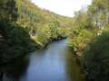
Hron is the second biggest Slovak river. It sources on slopes of Králova hola in Low Tatra Mountains in an altitude of 1005 m above sea level. At first, it flows in west diresction, latzer, in section Banska Bystrica-Zvolen, it turns towards south. after Žiar nad Hronom it turns again to the west, and finally, in its last section, it flows in south dircetion, up to its mouth to Danube-river, near to the town of Šturovo. River-basin makes nearly 5500 square kilometres, 271 kilometres are navigable.
Water index registers, decisive for judgment of river-navigability, are those, located in Brezno and Banska Bystrica. So, for descent of section Helpa-Závadka, water index register must show 50 cm, corresponding to 130 cm on water index register in Banska Bystrica. Section Brezno-Banska Bystrica is passable at 100 cm, from Banska Bystrica up to the mouth you can do it at 90 cm water-level, both showing in water register index in Banska Bystrica.
Accommodation:
It is available in Banska Bystrica.
Food supply:
It is available in communities of Helpa, Brezno, Podbrezová, Dubová, Banská Bystrica, Zvolen, Žiar nad Hronom, Nová Baňa, Jur nad Hronom, Kamenica nad Hronom.
First aid:
It is available in Brezno, Banska Bystrica, Zvolen, Nová Baňa and Štúrovo.
Places of interest:
- Helpa - this is typical village with people´s architecture and live folklore customs.
- Brezno - important industrial factory Mostáreň (bridge factory), Neo-classical town hall(museum), tower and church.
- Podbrezová - iron ore works, machinery factory Piesok.


