
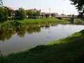
River Morava - Czech republic
The river sources under top of Kralický Sněžník in an altitude of 1380 m of sea level.
329 km
| Basic information about river river sections Kilometrage Localites | Services Article Fotogallery Videogallery | Discussion Water stages |
Localites
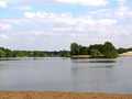
Route along Litovelské Pomoraví
Cycling of curve
Olomouc district
This route is of easy stage. We start from Olomouc along marked cycloroute No. 51. On your right part, there is placed nature monument Bázlerova pískovna (Bázler Sand-Quarry) and nature reservation Plané loučky (Wild Meadows). We drive around Poděbrady Lake (bathing possibilities) and continue further via community of Horky nad Moravou with nature reservation Panenský les (Virgin Forest), where endangered sorts of birds are nestling. We follow educative path Luhy Litovelského Pomoraví (Litovelské Pomoraví Meadow-Lands), arriving to the community of Lhota nad Moravou. Later, we follow marked cycloroute No. 6107, via Protected Nature Area of Litovelské Pomoraví, up to Štěpánov. Further, we pass nature reservation Chomutovské Lake. We reach the community of Chomutov and – between Poděbrady lake and nature reservation Plané loučky we return back to Olomouc.
Route length: 33 kms
Character: easy cycloroute


