
River Moravice - Czech republic
spring (source):
This river sources in Hrubý Jeseník in an altitude of 1087 m of sea level.
This river sources in Hrubý Jeseník in an altitude of 1087 m of sea level.
flow length:
97 km
97 km
| Basic information about river river sections Kilometrage Localites | Services Article Fotogallery Videogallery | Discussion Water stages |
River description:
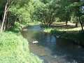
The river sources in Hrubý Jeseník in an altitude of 1087 m. It flows in southeaster direction up to Vítkov, where it turns to northeast. This direction is kept up to the mouth into Opava river. The length of navigable section is 100 kms.
The whole river-bed is stony, the river flows through marvellous countryside, first through Nízký Jeseník, near to Kružberk meanders around picturedque Oderské Hills. On the river, you find valley dam of Kružberk, however, the navigation here is not allowed. The upper section is to be recommended for experienced watermen, the best way is with the closed boat. The section under the dam is possible to descend with open boats, too.
The upper section is navigable during spring snow thaw or after heavy rains, the lower section is dependent on a situation when the water is let out from the dam (min. 7m³/sec.).
Food supply:
It is available in places: Velká Šťáhle, Břidličná, Valšov, Karlova Pláň, Slezská Harta, Kerhartice, Podhradí, Hradec nad Moravicí, Kylešovice.
First aid:
It is available in health centres in Břidličná and Hradec nad Moravicí
Places of interest:
Hradec nad Moravicí: castle with English park


