
River Mrlina - Czech republic
spring (source):
This river sources near to Příchvoj in an altitude of 378 m of sea level, under Čakan Hill.
This river sources near to Příchvoj in an altitude of 378 m of sea level, under Čakan Hill.
flow length:
51 km
51 km
| Basic information about river river sections Kilometrage Localites | Services Article Fotogallery Videogallery | Discussion Water stages |
River description:
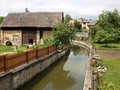
River Mrlina is navigable at moderately higher water levels, and in many cases all year round. The navigation is slow in average 4-5 kms in an hour.
The river sources near to příchvoj in an altitude of 378 m. It flows to the south and southwest and mouths to Elbe river from its right side. Its river-basin makes 642 km². Mrlina flows throughout agriculture countryside between meadows and fields in embanked river-bed.
The river has very quiet stream, the navigation is slow and safe. However, the bank overgrowns prevent the view on some places. Disadvantage makes a moderate pollution.
The weirs are not passable.
Accommodation:
All necessary you find in Nymburk, as to shopping or refreshment also in Rožďalovice and Křinec.
Food supply:
It is available in Nymburk, Rožďalovice and Křinec.
First aid:
It is available in health centres in Nymburk, Rožďalovice and Křinec.
Places of interest:
Křinec: early Baroque castle of 17th century, today it is a deposit.


