
River Otava - Czech republic
spring (source):
The river is created by confluence of Vydra and Křemelná rivers near to Čeňkova pila in Bohemia Forest.
The river is created by confluence of Vydra and Křemelná rivers near to Čeňkova pila in Bohemia Forest.
flow length:
113 km
113 km
| Basic information about river river sections Kilometrage Localites | Services Article Fotogallery Videogallery | Discussion Water stages |
Localites

Podskalí Educational Path
Locality type:
Educational path
Educational path
Place:
Strakonice district
Strakonice district
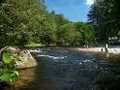
This route starts on left bank of Otava river. It leads around brewery, and below Velká skála. (Great Rock). The path passes towards right bank of the river ahead, via weir and an island. You walk in direction to Calvary, passing bust of writer F.L.Čelakovsky, and around castle garden towards Strakonice Castle. Most part of the castle is used as Central Vltava Museum. So, at the gate of the castle, your excursion could be finished.
This route is destined for foot passengers only, and it passable all year round. On the route, there are placed fourteen stops.
Route length: 3,5 kms


