
River Otava - Czech republic
The river is created by confluence of Vydra and Křemelná rivers near to Čeňkova pila in Bohemia Forest.
113 km
| Basic information about river river sections Kilometrage Localites | Services Article Fotogallery Videogallery | Discussion Water stages |
River description:
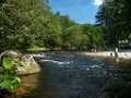
The river is cerated by confluence of Vydra and Křemelná rivers near to Čeňkova pila in Bohemia Forest. From here, it flows in northern direction to Sušice, and afterthat with big bend turns again via Horažďovice to the east. Before Písek, at mouth of Blanice river, it turns again to the north , and shortly before its mouth to Vltava river near Zvíkov, changes its flow direction to northeast. The length of the river makes 113 kms, and it is, at favourable weather conditions, completely navigable.
Accommodation:
It is possible to make a reservation in camping place Antýgl (4 kms distant from Čeňkova pila). Other possibilities in Sušice and along the flow.
Food supply:
It is available in Rejštejn, Annín, Sušice, Horažďovice, Katovice, Strakonice and Písek.
First aid:
It is available in health centres in Rejštejn, Sušice, Horažďovice, Katovice, Strakonice and Písek.
Places of interest:
Rejštejn: late Gothic church, rebuilt in Baroque style.
Sušice: production of safety matches (Museum), monuments of Gothic and Renaissance houses, Gothic cemetery church, Baroque monastery.
Rabí: ruins of a castle, guided tours bin a castle, trained birds – an entertainment mostly for children.
Prácheň: ruins of a castle of middle of 14th century.
Horažďovice: Gothic church.
Strakonice: early Gothic castle, Roman-Gothic church.
Písek: stone-bridge of second half of 13th century, part of early Gothic castle, Baroque Town Hall, Museum, Theatre.


