
River Sázavka - Czech republic
spring (source):
This river sources in western direction of Chotěboř, near to the community of Rankov, in an altitude of 558 m of sea level.
This river sources in western direction of Chotěboř, near to the community of Rankov, in an altitude of 558 m of sea level.
flow length:
31 km
31 km
| Basic information about river river sections Kilometrage Localites | Services Article Fotogallery Videogallery | Discussion Water stages |
River description:
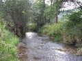
The river sources in western direction of Chotěboř, near to the community of rankov, in an altitude of 558 m. It mouths to Sázava river, from the right side, near to Světlá nad Sázavou.
Its river basin makes 133 kms. This small river flows first with moderate steram through flat valley, which successively encloses and cuts after into deeper valley between forests.
The river-bed is not wide, under Sázavka becomes stony with light rapids. The weirs are damaged, attention for a weir in Josefodol-factory, where flows the river.
Sázavka river is navigable at higher water level only, i.e. after snow thwa in spring or after heavy rains. The orientative estimation can be made according to Stvořidla rapides, if here there is enough water, so the sufficient water level will be also in Sázavka. However, the navigation could be complicated with trees laying in river-bed, so, the drive will be more slowly.
Accommodation:
You can find a suitable accommodation in Světlá nad Sázavou or Ledeč nad Sázavou.
Food supply:
It is available in Leština, Sázavka, Světlá nad Sázavou.
First aid:
It is available in health centre in Světlá nad Sázavou.
Places of interest:
Leština: carpentered granary of 16th century.
Světlá nad Sázavou: see Sázava.


