
River Jizera - Czech republic
The Jizera river sources in Poland round the border on slopes of Smrk and enters to the Czech territory at the altitude of 885 m of sea level.
164 km
| Basic information about river river sections Kilometrage Localites | Services Article Fotogallery Videogallery | Discussion Water stages |
River description:
The navigability of upper flow of Jizera river is depending on period of snow-thaw, it is in April and May The river is navigable after strong rain as well. Owing to the fact that in Jizerské Mountains are missing the forests , the river collects quickly the water and flows off smoothly. The number of days when there is plenty of water in river-bed, has increased, but the navigation-period became shorter. The navigability can be followed according to water-index in Železný Brod, where the indicator over 160 cm can present the navigability of upper Jizera from Mýto or Vilémov, the indicator 110 cm the navigability from confluence with Kamenice-river. When the water-index presents more than 180 cm you can drive from the uppermost section. The value of water-index is influenced by Kamenice-river and on the fact if the water is let flow from Josefův Důl-Dam. The navigability of the upper flow could be judged also according to water-index on bridge-pillar called „Na Mýtě“ , where 40 cm is a minimum, 60 cm is an optimal stand, and more than 80 cm the difficulty is increasing of one stage. The river has a character of Alps rivers, speed of stream is great and the water rollers are kept. The indication of 40 cm of water-index corresponds the indicator of water-index in Jablonec nad Jizerou. You can drive from this point when the water-index shows 30 cm. In the uppermost section – from Jizerka to railway-bridge – the river forms the state border with Poland , therefore could be some problems with the navigation. In the section from Mýto up to Jablonec the river flows through KRNAP (Giant Mountains Natural Park), there are signed the places where it is possible to enter the river. Under „ Island of Horror“ ( it is a name of difficult place , 1, 5 kms distant from Mýto), it is constructed the access path to the river from the main road. Attention on the passing cars, as there is no place for parking !(you have to stop and park along the road !) You find the other similar places in Vilémov and Paseky. All suitable places are marked with plates of waterman-picture. It is worth to respect these places. Except National Park the river flows, near the town of Semily, through Natural Park „Jizera Valley“. There is , however, limited access to the river. The navigation speed on the section from Jizerka II to the „ostrov-Island“ is for experienced and well equipped watermen 4 kms only. You have to investigate first and secure the difficult places (especially the section from Kořenov-bridge to Mýto and the passes near to Ostrov).
Further, the only obstacles there are the weirs, at several of them it is necessary to carry over the boats. You can calculate with the time of 6-8 kms in an hour , this is valid up to Semily. The section of „Rieger Path“ is recommended to be investigated first. The average speed in the plain part is 5-6 kms per hour.
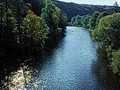
Jizera belongs to rivers of mountaineous character and is very popular with with watermen who navigate more difficult rivers. It springs in Poland near to the state border on slope of Smrk and enters the Bohemian territory in an alzitude of 885 m of sea level. It forms border-flow up to the community of Kořenov. Further, it flows to the south and southeast, near to Jilemnice it turns to the west and the direction keeps till its mouth into Elbe at Toušeň.
Its river-basin makes 2193 kms. From its spring, Jizera flows throughout table-land among peatbogs, and under Bukovec enters into enclosed valley , with boulders, cascades and high stages , forming the rapids of highest difficulty. In this section, the river creates the border of Giant Mountains National Park. Its slope as well as difficulty decreases subsequently towards the town of Semily. There are more often the weirs on the river, which are not navigable, however. Near to Semily the rive squeezes through short pass , along the banks leads well known touristic „Rieger Path“. Further to the town of Turnov, the river flows with its activ stream, and from Turnov it is a plain-river with moderate stream. The stream is quicker before its mouth to the Elbe-river, near to the town of Benátky. The river-bed is in its upper flow wide 10-20 m approx. , whereas on its lower flow reaches ithe width up to 50 m.
The river is surrounded by forests in its upper flow. Further, the river flows through meadows with willow trees on the banks.
Jizera-river has several navigable tributaries , the biggest is Kamenice, further Mumlava, Jizerka I, Jizerka II, Oleška, Žarnovník, Mohelka.
Accommodation:
You can reserve your accommodation – within weekend excursion – in many places.
It is a question of season and price. However, there are not many camping places along banks, from this reason the river is not used as a holiday-river.
The camping places can be found in Jablonec nad Jizerou, near to the mouth of Kamenice, and in Malá Skála, near to Dolánky.
Food-supply:
It is available in places: Kořenov, Jablonec nad Jizerou, Poniklá, Sytová, Háje, Loukov, Benešov u Semil, Semily, Železný Brod, Malá Skála, Turnov, Přepeře, Mnichovo Hradiště, Mohelnice, Bakov, Mladá Boleslav, Dražice, Benátky, Předměřice and Sojovice.
First aid:
It is available in health centres in Jablonec nad Jizerou, Semily, Železný Brod, Turnov, Mnichovo Hradiště, Bakov, Mladá Boleslav and Benátky nad Jizerou.
Places of interest:
- Paseky nad Jizerou: people´s carpentered architecture, the scene of „ Zapadlí vlastenci“ (Fallen Patriots).
- Rokytnice nad Jizerou: the tourist centre of West Giant Mountains, ski resort.
- Jablonec nad Jizerou: town of 14th century, starting-point to Giant Mountains.
- Semily: Baroque church of 17th century, rebuilt, Neo-romanesque church of 1908, museum.
- Železný Brod: wooden Gothic church of 14th century, rebuilt in Baroque style, Baroque ossuary of 18th century, people´s carpentered architecture, ethnographical museum. glass manufacture.
- Malá Skála: castle of 1700, the rests of castle Skála of 15th century, arranged in 19th century as Pantheon.
- Frýdštejn: the ruins of a castle of 14th century.
- Dolánky: people´s carpentered buildings (Dlask´s property of 18th century, the exhibition of Turnov´s Museum.
- Turnov: the tradition of jewels´grinding, the centre of Bohemian Paradies (Český ráj). Late Gothic town hall of 16th century, rebuilt in late Renaissance style, Gothic church of 14th century, rebuilt in Baroque style, Baroque monastery with a church of 18th century Museum of Bohemian Paradies.
- Mohelnice nad Jizerou: a Romanesque tribune-church of 12th century, the ruins of Renaissance castle Zásadka of 16th century.
- Mnichovo Hradiště: Baroque castle of 17th century with a museum, the complex of Capuchin-monastery with a church, chapel and a tomb of Albrecht of Wallenstein, the towns´natural reservation.
- Skalní sruby Jizery: the caves, important of morphologic point of view on banks of Jizera, near to Mnichovo Hradiště.
- Bakov nad Jizerou: two originally Gothic churches rebuilt several times, Baroque column with statues.
- Zvířetice: the ruin of Gothic churchof 14th century.
- Mladá Boleslav: the town´s preserve zone, the castle rebuilt in Renaissance style with a museum, town hall in Neo-romanesque style, Baroque church of 15th century, Jewish cemetery.
- Vinec: Romanesque tribune-church of 13th century.
- Horky nad Jizerou: Renaissance castle rebuilt in Baroque style. Baroque church with Rococo chapel.
- Dražice nad Jizerou: ruin of a castle of 13th century, Baroque church of 14th century.
- Benátky nad Jizerou: the town´s preserved zone, Renaissance castle of 16th century, rebuilt in Baroque style with a museum, three Baroque churches, Neo-Renaissance chapel.
- Krnsko: Baroque church of 18th century with a Renaissance castle of 16th century, rebuilt in Baroque style.


