
River Jizera - Czech republic
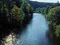
The Jizera river sources in Poland round the border on slopes of Smrk and enters to the Czech territory at the altitude of 885 m of sea level.
164 km
| Basic information about river river sections Kilometrage Localites | Services Article Fotogallery Videogallery | Discussion Water stages |
Localites
Jizerka
Cycling of curve
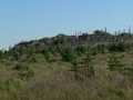
Jizerské Mountains
This cycloroute is quite easy. You can start from parking place Bukovec, near to the community of Jizerka. You drive along narrow way in direction to north-west. You turn to the left on Lasice cesta (Weasel Way), immediately turn aside to the right ,and so you ride round the Central Jizera Range. On right part, you can see Jizera river, which forms here state border. Before Rybí ločka (Fish Meadow) the way is disuniting, but you can choose your way at any direction you wish, as later both ways and joined again. You pass characteristic rocky formation known as Houba (Mushroom) and reach crossroads Zelený kámen (Green Stone) shortly. From here, you continue along Fir-tree path and drive to Smědava. From here, you drive around Jizera peak, following Kasárenská silnice (Barrack road) into a col. From here, you follow blue marked tourist trail up to the place Čihadlo. Later, you descend through Bílá Desná (White Desná) - river valley to Mariánskohorské cottages. From breached dam, you follow yellow marked tourist path, across Souš-Smědava road up to Vlašský Range. Further, you continue tho the left and up, mounting the hill. You reach so called promenada way, turn aside to the right and arrive to parking place near Bukovec, where your route was started.
Route length: 47 kms
Character: easy route


