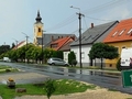
SK, Bratislava – Starý Háj, A Petržalka Island
Published: 8.4.2020
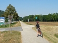
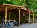
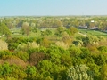
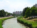
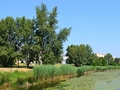
The largest housing estate in Slovakia - Petržalka in Bratislava - hides many natural corners. One of them is the nature reserve Starý háj, which is located in the eastern part of Petržalka, not far from the Danube cycle path (Eurovelo 6).
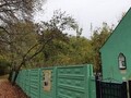
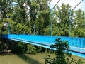
The Starý háj Nature Reserve (declared in 2005) is actually an old Danube island surrounded by a river branch. During the journey we will talk more about its origins and changes. The best way to get there is an unmarked forest road opposite the Slovnaft pump (Mamateyova bus turn, Ovsište), which crosses the already mentionedDanube cycling route. Access is also possible from the protected area of Hrabiny (approximately 700 meters along the cycle path towards the Port Bridge). There are many more unmarked routes, but these are ideal for both pedestrians and cyclists.

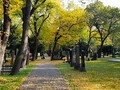
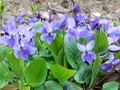
Right at the beginning you will be enchanted by the primeval character of the area. You will get to the paradise of floodplain forests, where besides the huge trees there are also numerous flora, lianas enclosing branches, insect buzzing bushes or grasses. In one word, perfect and wild nature. As it is a flat terrain, the trip can be taken by complete tourist beginners and small children.


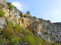
The whole area of the Old Grove is in the 4th and 5th degree of protection. In addition to forests, you will find stone and sandy "beaches", grassy plateaus, numerous outbreaks, water bodies, and even a military bunker.
")
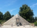
The origin of the present island dates back to the mid-18th century, when the Danube riverbed changed frequently due to human influence and hydrogeological manifestations. Regular leaching of the river with tearing down the whole forest strips as well as creating new river branches led to several opposite turns - meanders. The accumulation of gravel and sand has also changed the terrain. Over the years, the area has undergone several modifications - whether in the form of peripheral dam construction, gravel mining, or building a defensive line.

The defensive line is still preserved in the form of a concrete bunker on the southern tip of the island. This military monument from the time of the First Czechoslovak Republic is a memento for the turbulent events in Central Europe that resulted in the Second World War. The bunker bears the name B-S 15 "Island" and once closed the arch line of military fortifications to protect Petržalský beachhead. The building built in 1937 is in a desperate state today and unfortunately it is not very flattering.
")
")

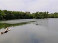
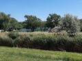
In addition, you will find the dead arm of the Danube called Zuzana, which offers a glimpse of the past, where the fallen trees remained in place, creating breathtaking scenery.

The Petržalský forest is a true oasis of peace and joy. It will give you a lot of the energy that every one of us needs in the current world affected by the spread of coronavirus, so we definitely recommend visiting the island green.

GPS: 48°07'00.2"N 17°08'01.6"E (the beginning of the access road close to gas station)
GPS: 48°06'01.8"N 17°08'15.5"E (B-S 15 „Island“ bunker)
Text and photos: Oskár Mažgút

Related Articles
Published: 24.7.2013
Bike – a simple machine on two wheels; we decided to use it during our summer vacation to explore beauties of nature, history of various places and last but not least to get fitter. Come with us to this unusual bike trip, which starts at the largest housing development, Petrzalka, and ends in Wolfsthal, a picturesque Austrian village.
Published: 19.12.2021
We invite you for a walk through one of the most popular and most beautiful public parks in Bratislava. It is located in a relatively densely built-up area of the Old Town and is called the Medical Garden, which aptly describes the surrounding presence of a polyclinic, school or dean's office at the Comenius University Faculty of Medicine.
Published: 20.12.2021
The Old Town has few corners to hide from the hustle and bustle of the streets. You can go to one of the public parks, for a walk through the medieval Kapitulská Street, or to the castle. However, today we will take you to the historic cemetery located near the newly built shopping and administrative center of the city or the popular Medical Garden.
Published: 3.4.2022
In the southwestern part of Slovakia, beyond the capital Bratislava, there is the sunniest village in the landscape - Ivanka u Dunaje. In terms of population, it is the second largest municipality in the Senec district, the Bratislava region, and even belongs to the top five most numerous municipalities in Slovakia. Accept the invitation for a short walk through their sights and picturesque nooks.
Published: 5.5.2021
Lovers of walks and tourist enthusiasts can look forward to a completely new and at the same time unique mobile application that will take you to many unknown places in the Bratislava Forest Park using an interactive map.
Published: 18.4.2021
Do you know what the streets and squares of Bratislava looked like 300 years ago? Can you imagine what its inhabitants fed and what life was like at that time in the streets and houses of rich and poor citizens? The new book publication "Bratislava-known-unknown" will show us how and what the city lived in in the 18th century and at the same time allow us to peek into various corners.
Published: 2.9.2015
Once we rode on bikes from Petrzalka across the Pristavni Bridge along the Small Danube and across Vrakunsky forest we found ourselves at the airport. From there we will continue to our first place of interest the M. R. Stefanik Memorial.
Published: 10.4.2024
With its area of 2052.6 km², the Bratislava Region is the smallest of all regions of Slovakia. As for natural or historically valuable places, it certainly does not lag behind others.
Published: 22.11.2020
Only recently have Petržalské hájovny become important forestry places, thanks to which they have been partially restored, they have once again become known not only to locals and they provide us with a forgotten view of the past.
Published: 29.11.2020
Last week we introduced the Petržalka gamekeeper's lodges, today we will go to perhaps the most popular lakes in Bratislava, where you can fish, take a walk and take a bath in the summer. But there are no limits to swimming, you can also use the lakes for hardening, which is very modern at this time.
Published: 6.12.2020
It has been a week since we invited you for a walk around the Petržalka lakes for the first time. We visited Velký Draždiak, which changes mainly during the summer to a popular recreational location with the possibility of swimming, refreshments and sports activities.
Published: 28.9.2014
At the beginning of September by bike we went toe explore Slovakian-Austrian-Hungarian borderline. The beginning of our trip was in Petrzalka, the largest housing estate in Slovakia and central Europe as well.
Published: 2.11.2014
As winter is coming and cold, rainy, or snowy weather with it, we decided to end biking season by a trip to the Hungarian town of Mosonmagyaróvár. The beginning of our tour was yet again in Petrzalka, a Bratislava borough.
Published: 26.10.2014
Last week we visited an extraordinary place- Trojmezi, a unique place where the borders of three countries meet, Slovakia, Austria, and Hungary. From there, we moved to Hungarian border town of Rajka. Today we will tell you more about it.
Published: 26.8.2015
Even this year, we spent some summer days on our bikes. As we live in Petrzalka, this area of blocs of flats is the point from where we start our trips.
Published: 24.4.2014
One of the most densely populated areas in Slovakia and even in the Central Europe has several unusual natural nooks. One of them is forest Stary Haj, that was declared protected landscape area. To this very forest we go today.
Published: 8.8.2013
Petrzalka is the largest and densest district in Bratislava, also it is the largest housing development in central Europe. Many called it a “concrete jungle” in the past, however, today there is not only vast greenery but also several interesting natural sights located just among houses or nearby.
Related Photogallery
Accept the invitation for an autumn walk through the historic Ondrejský Cemetery, which was found...
Today we invite you to a tour of the parish Roman Catholic Church of St. Vincent located on Tomáš...
We invite you on a trip to the Petržalka lakes, which you will find on the edge of a relatively d...
Today we will take you to the largest housing estate in Slovakia - Petržalka in Bratislava. But i...
Maybe you will be suprised but Bratislava has many beautiful places in nature. Join us for a tour...
In case you love to watch nature in spring take a look at our gallery showing you Rusovce. There ...
On the second weekend of October all fans of Infoglobe and Slovakian Paleontological Club decided...
Stary Haj in Petrzalka is a green oasis in the middle of the largest housing estate in Slovakia. ...
Croatian branch is a channel going through Bratislava's district of Petrzalka. It was built withi...
In the previous photogallerywe hopped on our bikes and admired beauties of nature and interesting...
Bratislava and its surroundings offer great possibilities for bike tourism thus we (the Infoglobe...


")
")