CZ, Brdy – Cross-Country Skiing Around Pilsky Pond
Published: 21.2.2019
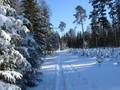
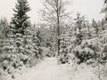
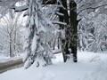
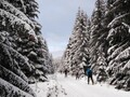
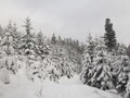
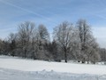
Snowy Brdy have their magic, and more and more cross-country skiers are attracting in the winter season. There are many forest paths in the area in the winter, and if you are lucky, you will also find traces of trails. You can go for example up the dominant of the region of Pribram - Tremosna or somewhat deeper into the Brdy forests up to Skelna Hut.
Výlet na Třemošnou
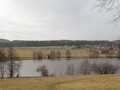
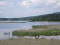
If you are going to Tremosina in winter, it is best to choose the way from Rovina klippe. You can get it either from Obecnice, Bohutinor Kozicin. If you choose the second option, you will pass through the Pilska Water Reservoir. There has recently been a new tourist landing, from which this water reservoir has a nice view. From Rovina, continue along the forest road, from which turn the blue tourist sign towards Pilas Fountain. The road rises to the right and after about 1.5 km you will find yourself at the crossroads. There is an emergency call and a tourist landing.

On Tremosna there is a forest path called Tremoshenská. In particular, the first stretch of the path rises, but then passes mainly along the contour. The road leads to the next crossroads just below the summit of Tremosna, where it turns slightly to the left. On the left there is a view of Tok military shooting range area. Then you just need to turn steep to the right and climb a rather steep hill to the top of Tremosna.
Skelna Hut
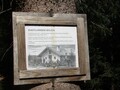
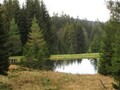
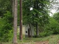
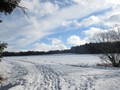
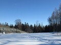
You can also go to Skelna Hut from the Pilsky water reservoir. This meadow enclave lies between Zavírka and the sixth largest brick peak (Brdce) and formerly the glassworks belonging to the Adler family. The first few tens of meters of this route coincide with the trip to Tremosna, but at the first junction behind the reservoir it is necessary to turn left to Pilska Well. Just across from it there is a crossroads, where the blue tourist sign turns to the left on a forest path named Perkanska, at Skelna Hut it is about 2.5 km away. The path first descends into the valley of the Pilský potok, then again rises up the forest.


From the busy traffic today, there is only a barn, a little pond near the signpost and a well. The entire deforested area has an area of more than ten hectares and acts a bit mysteriously in every season. Whoever has enough strength can continue from here to the crossroads of St. John, from where it is only a short distance to the second highest peak of the Brdy which is called Praha. From here you can easily reach the edge of Láz, the road leads directly around the Lazsky water reservoir, and go back to the Struma Forest Way back to the Pilsky water reservoir.

What Not to Forget?
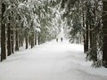
In addition to what is mentioned in almost every article about the , meaning a paper map, warm clothes and a snack, you can surprise some fallen trees or wood mining. Also, encounters with high game are frequent in the Brdy. In the season, the main forest paths are covered, trails are frequented on frequented trails. Compared to previous years, significant tourist routes have also improved significantly.


GPS: 49°40'47.0"N 13°54'09.8"E
Text and photos: Eliška Gregorová

Related Articles
Published: 19.8.2021
Although Hradiště is one of the highest peaks in Brdy, it is not very visited, which is probably due to the absence of any tourist sign leading to its peak. But it would be a pity to miss it, it is beautiful in the local forests in every season.
Published: 5.11.2020
The Brdy village of Vacíkov became known mainly due to the activities of the local civic association fighting gold mining on Petrášek Mountain. The good news is that his efforts are not in vain and we can go to the forests around Vacík full of mushrooms, forest fruits and also many historical and natural attractions even today.
Published: 19.11.2020
I have been going to the Brd area for a very long time. I read a lot of articles about this mysterious area and wanted to explore it with my own eyes and also with my own feet on a bicycle.
Published: 31.12.2020
Jedová hora is located near Hořovice near the famous castle Valdek. Easy access and interesting surroundings make it an ideal tip for a trip to Brd. Feel free to do so in December.
Published: 21.1.2021
Although the closure lags behind the highest peaks in Brdy, thanks to its convenient location near Skelná Hut and Pilská Reservoir, it is also an ideal place for a shorter winter cross-country trip.
Published: 28.1.2021
Cross-country skiing is the number one winter activity this year due to the closure of downhill skiing and snowboarding centers. However, the popular Jizera Mountains are already bursting, especially on weekends at the seams. But where else to go for a nice run? Ore Mountains, for example, are offered.
Published: 20.2.2024
Downhill skiing or snowboarding is probably not waiting for us this year, but cross-country skiers also offer great variety in these times. Today we will go to the Jizera Mountains. Cross-country skiing conditions are great, tracks beautifully prepared.
Published: 20.2.2021
Prague is a popular tourist destination in Brdy, a hike to this hill can be combined with a trip to other nearby peaks such as Malý Tok or Hradiště. The big advantage is that once you climb to Prague, it will be easy for you to reach other interesting places in the area.
Published: 18.3.2021
As soon as it is possible to move freely around the republic, we recommend this beautiful trip to nature. Both mentioned peaks belong to the popular and frequently visited areas of Brd, they offer views of the Litavka valley, Příbram and the surroundings rich in natural monuments.
Published: 22.7.2021
Although Kokšín is not one of the highest peaks in Brdy, it is a characteristic feature of the Spálenopoříč region, in addition, it is easily accessible from the surrounding villages and boasts not only beautiful forest stands.
Published: 20.10.2020
Koruna is located in the heart of Brdy near Strašice and belongs to the group of Brdy octopuses. In addition to beautiful forests and nature, the place also boasts an interesting history.
Published: 15.10.2020
It's quite cold outside, but would you still like to go on a bike ride? The next bike trip we completed was around a picturesque landscape full of forests near Mníšek pod Brdy and it was definitely a very good choice.
Published: 6.8.2020
Vrch Nad Maráskem is located near the village of Míšov in the southern part of Brdo and is not one of the most famous. Which is a shame, because it offers great views and a walk through the surrounding forests, but at this time it is rather a welcome fact. You will avoid crowds of excursionists. A hike to this hill can easily be combined with a visit to nearby Třemšín.
Published: 26.3.2024
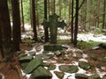
Zavírka and Linkův Cross are among the most mysterious places in the Brdy, which are associated with many legends. In winter you can also get to Zavírka on cross-country skis and the mysterious Link Cross will be best sought during the period of vegetation calm, so both places are ideal tips for a winter trip to Brdy.
Published: 26.9.2019
Kloboucek is a bit in the shadow of Tok, Prague, Tremosna and other known peaks, but it is definitely worth a visit. Kloboucek is easily accessible from nearby Obecnice and a new forest trail leads to it.
Published: 16.4.2024
Outside everything blooms, birds sing and everything is kind of cheerful. After a long winter, most of us long to go out into the wild and enjoy the first spring rays. With us you can go for one such walk.
Published: 28.3.2019
Praha is an easy-to-spot hill towering above Nepomuk, behind the highest mountain of the Brdy - Tok. It lags behind only three meters. On its top is a meteorological radar and there are also remains of a German radar station.
Published: 13.2.2023
The Brdy is a place to visit not only in summer. They are magical as well when covered in snow. Both Houpak and the former Jordan impact area were only recently opened to the public. Houpak is an ideal place with perfect panoramatic vista. People who like long trips will love it here.
Published: 27.2.2024
Don't worry and go to the Brdy in winter as well. Local landscape is beautiful in any season of the year.
Published: 10.12.2015
In the beginning of the year 2016 there will be the last chance for tourists to walk in a vast forest area they have never been to before. There are not even signs for tourists. The closed military area of Brdy will be open to the public. It means that only 90 kilometers from the south end of Prague you will have an opportunity to walk somewhere beyond Rozmital through the woods without stumbling upon any settlement or a busy road!
Published: 11.10.2018
The dams on the Litavca River situated in the Brdy region were founded for the needs of the mines of Pribram. Today, these reservoirs feed Pribram and surrounding towns and villages with water.
Published: 15.11.2018
The largest pond in the Pilsen region is located in the middle of the Brdy forests and not far from the remains of many defunct sites.
Published: 28.9.2017
In the comming weeks we are about to see some of the most beautiful places in Brdy. First, however, we talk about Brdy protected nature area in general. It is one of the newest protected nature areas in the Czech Republic being established in January 2016. Therefore, areas which were of once restricted access.
Published: 12.10.2017
Plešivec, výrazný protáhlý kopec v blízkosti Jinec, není možné přehlédnout. Místo patří k těm nejtajemnějším, jaká můžeme v Brdech najít. Váže se k němu mnoho pověstí.
Related Photogallery
In the following photo gallery we will take you again to the picturesque the Brdy. You will have ...
We invite you to a year-round walk through the largest inland mountain range in our country, whic...