
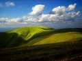
Vel'ká Fatra (High Fatra) - Slovakia
Extent: 784 square kilometres
High Fatra is located in Central Slovakia, in Fatra-Tatra Area , in districts of Martin, Ružomberok, Dolný Kubín and Turčianske Teplice. This mountain range forms a part of Internal West Carpathian Mountains.
Highest peak: Ostredok (1592 m).
Surface: remarkably afforested, the forests are mixed and of beech-woods, less pine-woods.
In high levelled sites, there are to be found plough-tails and pine forests. The areas, where trees are missing, are covered with meadows, Alp-meadows and glades.
Climatic zone: it is mostly cold.
Mountain relief is very rough, montaneous, in lower sites is hilly. The nucleus is formed with rests of granite and granite eruptives, wrapped up mostly with limestone, on some places even with karst appearances.
In this mountain range, there are to be found many of mineral as well as thermal springs.
High Fatra was declared as Protected Countryside Area in 1973, and later, in 2002, declared as National Park, especially thanks to its local fauna and flora.
| Lokalities Subjects | Articles Photogalery | Videogallery Discussion |
Photogalery
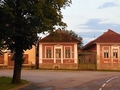
SK, Mosovce - Royal Village
In the center of Turcianska Basin is picturesque village of Mosovce. The village offers an unusual sightseeing. For example, you can see a late-Rococo/Classicist chateau built in the second half of the 18th century, or the birth house of Jan Kollar with famous table saying: "Slávme slávne slávu Slávov slávnych" (Celebrate famously fame of Slavs the famous). Or there is a sacral masterpiece - Gothic catholic church of the Holy Trinity and its tower, well today rather a torso, to its left side. Unique is also an English park. You can see there a beautiful Classicist pavilion and find the way to the island of Love. So don’t hesitate anymore. Join us to see Mosovce at least in digital form.
Text and photo: Oskár Mažgút
 |  |  |
 |  |  |
 |  |  |


Mountains / Europe / Slovakia

Important Information:
![]() Information and warnings on travelling abroad is to be found HERE.
Information and warnings on travelling abroad is to be found HERE.
Mobile application:

![]()
![]()


