
Vel'ká Fatra (High Fatra) - Slovakia
Extent: 784 square kilometres
High Fatra is located in Central Slovakia, in Fatra-Tatra Area , in districts of Martin, Ružomberok, Dolný Kubín and Turčianske Teplice. This mountain range forms a part of Internal West Carpathian Mountains.
Highest peak: Ostredok (1592 m).
Surface: remarkably afforested, the forests are mixed and of beech-woods, less pine-woods.
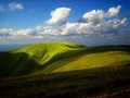
In high levelled sites, there are to be found plough-tails and pine forests. The areas, where trees are missing, are covered with meadows, Alp-meadows and glades.
Climatic zone: it is mostly cold.
Mountain relief is very rough, montaneous, in lower sites is hilly. The nucleus is formed with rests of granite and granite eruptives, wrapped up mostly with limestone, on some places even with karst appearances.
In this mountain range, there are to be found many of mineral as well as thermal springs.
High Fatra was declared as Protected Countryside Area in 1973, and later, in 2002, declared as National Park, especially thanks to its local fauna and flora.
| Lokalities Subjects | Articles Photogalery | Videogallery Discussion |
Photogalery
SK: Trips for Biking around Socovce Village
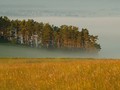
Today we will take you to the surroundings of the picturesque village of Socovce in the region of Turciany, which offers amazing natural scenery in the form of meanders of the River Turiec, the majestic mountains of the Great and the Small Fatra mountain ranges or the local hill Stráža. Morning foggy views of the Klášterní Meadows are also an unforgettable experience. Take a look at the mysterious beauty we caught from the bike saddle and get inspired by the trip.
Text: Oskár Mažgút
Photos: Karol Kobella (www.karolkobella.sk)
") | ") | ") |
") | ") | ") |
") | ") | ") |
")
")
")
")
")
")
")
")
")
")
")


Mountains / Europe / Slovakia

Important Information:
![]() Information and warnings on travelling abroad is to be found HERE.
Information and warnings on travelling abroad is to be found HERE.
Mobile application:

![]()
![]()


