
Vel'ká Fatra (High Fatra) - Slovakia
Extent: 784 square kilometres
High Fatra is located in Central Slovakia, in Fatra-Tatra Area , in districts of Martin, Ružomberok, Dolný Kubín and Turčianske Teplice. This mountain range forms a part of Internal West Carpathian Mountains.
Highest peak: Ostredok (1592 m).
Surface: remarkably afforested, the forests are mixed and of beech-woods, less pine-woods.
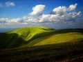
In high levelled sites, there are to be found plough-tails and pine forests. The areas, where trees are missing, are covered with meadows, Alp-meadows and glades.
Climatic zone: it is mostly cold.
Mountain relief is very rough, montaneous, in lower sites is hilly. The nucleus is formed with rests of granite and granite eruptives, wrapped up mostly with limestone, on some places even with karst appearances.
In this mountain range, there are to be found many of mineral as well as thermal springs.
High Fatra was declared as Protected Countryside Area in 1973, and later, in 2002, declared as National Park, especially thanks to its local fauna and flora.
| Lokalities Subjects | Articles Photogalery | Videogallery Discussion |
Photogalery
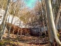
SK, Velka Fatra – A Hike Up Tlsta
Take a tourist climb with us to the majestic Velkofatranský peak Tlstá. Our starting point will be the picturesque Turčianská village of Blatnica, from where we will head through the Gaderská and Vápenná valleys to the limestone massif. Along the way, we will also pass a paleontologically or archaeologically significant natural monument - the Mažarná Cave. We will also enjoy breathtaking views of the surrounding peaks or the haze covered basin.
Text: Oskár Mažgút
Photos: Karol Kobella (www.karolkobella.sk)
 |  |  |
 |  |  |
 |  |  |


Mountains / Europe / Slovakia

Important Information:
![]() Information and warnings on travelling abroad is to be found HERE.
Information and warnings on travelling abroad is to be found HERE.
Mobile application:

![]()
![]()


