
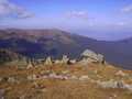
Nízké Tatry (Low Tatra Mountains) - Slovakia
Extent: 1258 km²
This mountain complex is most extended mountain range of Slovak Republic and take its central part in districts of Liptovský Mikuláš, Brezno, Ružomberok, Banská Bystrica and Poprad. The nucleus of this West Carpathian Mountain Range is formed with granite and crystalic slates.
Highest peak: Ďumbier (2043 m)
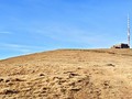
Surface: in its northern part, it is formed mostly with pine-wood forests, in its southern path, there are to be found leafy-woods and beech-tree forests, whereas in higher locations plough-tail is prevailing.
In the area, there are open for public ice-caves, such as: Demanovská Cave of Freedom, Demanovska Ice Cave, Važec Cave, Bystrianska Cave and Cave of Dead Bats.
Low Tatra Mountains are declared as National Park, thanks to local rare and variegated fauna and flora.
| Lokalities Subjects | Articles Photogalery | Videogallery Discussion |
Articles

SK, Liptovský Mikuláš – Infofest Festival which Brought the Best from Around the Globe
SK: Low Tatras – Autumn Trip Up Kralova Hola
SK, Kralova Lehota – A Town on the River Confluence
SK, Maluzina – Mountain Town with Roots in Mining
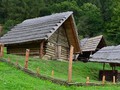
SK, Liptov – Havranok Open Air Archeological Museum and a Solitary Tower
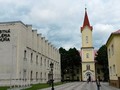
SK, Liptovsky Mikulas – Namesti Zadosti Slovenskeho Naroda Square
SK, Liptovsky Jan – Extraordinary Town in the Liptov Region
SK, Liptovsky Mikulas – The Town of Olympic Winners and More III
SK: Liptovsky Mikulas – The Town of Olympic Winners and More II

SK, Liptovsky Mikulas – The Town of Olympic Winners and More I


Mountains / Europe / Slovakia

Important Information:
![]() Information and warnings on travelling abroad is to be found HERE.
Information and warnings on travelling abroad is to be found HERE.
Mobile application:

![]()
![]()


