
Nízké Tatry (Low Tatra Mountains) - Slovakia
Extent: 1258 km²
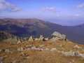
This mountain complex is most extended mountain range of Slovak Republic and take its central part in districts of Liptovský Mikuláš, Brezno, Ružomberok, Banská Bystrica and Poprad. The nucleus of this West Carpathian Mountain Range is formed with granite and crystalic slates.
Highest peak: Ďumbier (2043 m)
Surface: in its northern part, it is formed mostly with pine-wood forests, in its southern path, there are to be found leafy-woods and beech-tree forests, whereas in higher locations plough-tail is prevailing.
In the area, there are open for public ice-caves, such as: Demanovská Cave of Freedom, Demanovska Ice Cave, Važec Cave, Bystrianska Cave and Cave of Dead Bats.
Low Tatra Mountains are declared as National Park, thanks to local rare and variegated fauna and flora.
| Lokalities Subjects | Articles Photogalery | Videogallery Discussion |
Lokalities
Demänovská valley
Nature places of interest
Liptovský Mikuláš district
This national nature reservation has an extent of 836,9 ha and it is located in Low Tatra Mountains. It belongs to popular tourist targets, thanks to its rock localities, vast cave systems, preserved pine-tree forests as well as rare fauna and flora. The valley is full of marked tourist trails and pavements.
During mounting, you can see the mountains, as follows. Krupova hola (1927 m), Ďumbier (2043 m), Chopok (2024 m) and Dereše (2004 m).


Mountains / Europe / Slovakia

Important Information:
![]() Information and warnings on travelling abroad is to be found HERE.
Information and warnings on travelling abroad is to be found HERE.
Mobile application:

![]()
![]()


