
Muráň Table - Land - Slovakia

Site:
Muráň Plateau is situated in north part of Slovak Ore Mountains, in Region of Banska Bystrica, in Brezno, Revúca and Rimavská Sobota districts. Muráň table - land, together with Slovak Paradise, belongs to complex of Spiš-Gemer Karst, which forms a part of Internal West Carpathian Mountains.
Extent:
203,18 square kilometres, its protected belt makes 216,98 square kilomentres
The highest peak:
Klak -1409 metres above sea level (small complex of Muráň table - land)
Fabova Hola - 1439 metres above sea level (inside National Park Muráň table - land)
| Lokalities Subjects | Articles Photogalery | Videogallery Discussion |
Articles
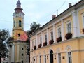
SK, Tisovec – Malohontské Mining Town
Published: 5.9.2021
This time we will head to the foot of the Slovak Ore Mountains and to the river Rimava, where the town of Tisovec lies. The first written mention dates from 1334 and its history is closely connected with mining, more precisely with the mining of silver, iron ore and later limestone.
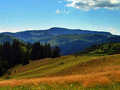
Throughout Murán Plateau
Published: 8.10.2010
We definitively leave picturesque countryside of Slovak Paradise, and after visit of Dobšiná Ice Cave, we transfer towards Low Tatra Mountains, where our active holiday will continue. But, between Low Tatra and our starting position, you can find a region, the beauty of which could not be omitted in any case, and if you are not in a hurry, you can make a small branchline.


Mountains / Europe / Slovakia

Important Information:
![]() Information and warnings on travelling abroad is to be found HERE.
Information and warnings on travelling abroad is to be found HERE.
Mobile application:

![]()
![]()


