
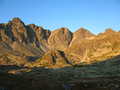
Vysoké Tatry (High Tatra) - Slovakia
Extent: 74111 ha
In north part of Slovakia, along borders with Poland, in districts of Kežmarok, Liptovský Mikuláš, Poprad and Tvrdošín, there is situated mountain range of special character – High Tatra. It belongs, together with Belianske Tatra, to complex of East Tatra Mountains.
Highest peak: Gerlachovka (2655 m).
Surface: it is formed with dense forests, pine woods. In higher sites, there are to be found dwarfish pine woods, plough-tails and lichens. Alp-meadows are located in places where the trees are missing.
Climate: mostly cold, 0 Celsius degrees. The snow remains on surface nearly all year round, on some places does not thaw at all.
Mountain nucleus is formed with granites and crystalic slates, on surface with limestones and sandstones, with appearance of quartz.
Mountain relief is very rough, including steep shields and combs.
We find here caves with karst appearances, waterfalls, lakes (plesa), healing springs, rare plants and many animals, in form of great mammalia.
High Tatra Mountains were declared as Tatra National Park in 1948. Later, in 1993, declared as biospherical reservation within scope of international UNESCO programme.
| Lokalities Subjects | Articles Photogalery | Videogallery Discussion |
Photogalery
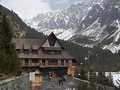
SVK: High Tatra Mountains - From Lake To Lake
High Tatra Mountains are beautiful during any year saison. Despite the fact that during our walk from Štrbské Lake to Poprad Lake no sun was shining and the sky was covered with clouds, and a drizzle with small snow fall was changing, this short walk in fresh air gave us enough forces, in order so called „spring exhaustion“ could be overcome.
The photos wre made at the end of March 2011.
Text/foto: O. Kubáčková
 |  |  |
 |  |  |
 |  |  |


Mountains / Europe / Slovakia

Important Information:
![]() Information and warnings on travelling abroad is to be found HERE.
Information and warnings on travelling abroad is to be found HERE.
Mobile application:

![]()
![]()


