
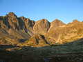
Vysoké Tatry (High Tatra) - Slovakia
Extent: 74111 ha
In north part of Slovakia, along borders with Poland, in districts of Kežmarok, Liptovský Mikuláš, Poprad and Tvrdošín, there is situated mountain range of special character – High Tatra. It belongs, together with Belianske Tatra, to complex of East Tatra Mountains.
Highest peak: Gerlachovka (2655 m).
Surface: it is formed with dense forests, pine woods. In higher sites, there are to be found dwarfish pine woods, plough-tails and lichens. Alp-meadows are located in places where the trees are missing.
Climate: mostly cold, 0 Celsius degrees. The snow remains on surface nearly all year round, on some places does not thaw at all.
Mountain nucleus is formed with granites and crystalic slates, on surface with limestones and sandstones, with appearance of quartz.
Mountain relief is very rough, including steep shields and combs.
We find here caves with karst appearances, waterfalls, lakes (plesa), healing springs, rare plants and many animals, in form of great mammalia.
High Tatra Mountains were declared as Tatra National Park in 1948. Later, in 1993, declared as biospherical reservation within scope of international UNESCO programme.
| Lokalities Subjects | Articles Photogalery | Videogallery Discussion |
Photogalery
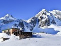
SK: High Tatra – In the Winter Realm of Mala Studena Valley
Malá Studená valley is one of the most popular places in the High Tatras. Skialpinism is very popular activity around here. However, here you may also do some winter mountain hikes. The green tourist trail running to Mala Studena valley and up to Tery cabin. It is open for tourists all year-round, even in the winter season when majority of trails in the Tatranian National Park. This gallery takes you to Mala Studena valley area – to inhospitable yet beautiful winter realm.
Text and photos: Radoslav Biskupič
 |  |  |
 |  |  |
 |  |  |


Mountains / Europe / Slovakia

Important Information:
![]() Information and warnings on travelling abroad is to be found HERE.
Information and warnings on travelling abroad is to be found HERE.
Mobile application:

![]()
![]()


