
Slovakia Paradise (Slovenský ráj) - Slovakia
Extent: 19 736 ha
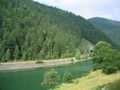
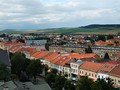
This mountain range forms part of Slovak Iron Ore Mountains, belonging to complex of Spiš-Gemer Karst. It is located in north part of Slovakia in districts of Spišská Nová Ves and Poprad. It is made from limestones and dolomites, and partially from sandstones and slates.
Highest peak: Ondrejisko (1270 m)
Surface: is afforested, in south there are to be found fir-woods and beech-woods, in north pine-wood forests.
All this area is very popular and visited by tourists, including its nature beauties and karst caves, canyons and precipices.
Protected Countryside Area Slovakian Paradise was declared as National Park in 1988.
| Lokalities Subjects | Articles Photogalery | Videogallery Discussion |
Articles
SK, Slovakian PAradise – Kláštorská Gorge
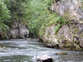
After approximately 20 minutes of easy walking, during which you will pass several fast food, accommodation facilities or the overgrown monument of Marián Slabaš, you will reach the above mentioned crossroad (the mouth of the Great White Water). From here you will join the Průlom Hornádu Nature Trail, which is part of the National Nature Reserve.

")


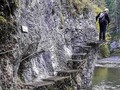
Before you know it the journey begins to take on adventure. The first risers in the rock wall, a little further chains, log cabin, small cave (Mníchová), wooden bridges, etc. Gradually you go to the other side of the Hornád and after less than an hour walk slowly to the mouth of the monastery gorge.
")
")

You have two options to choose from. You can either follow the unique rope bridge and complete the passage of the Hornád Breakthrough, or choose to climb the Monastery Gorge. We climbed a breathtaking gorge created by a stream that springs below Kláštorisko and flows directly into Hornád. The gorge was opened to tourists in 1960.


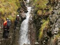
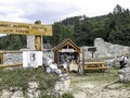
Although the gorge is relatively short, it offers many steep sections. Gradually you climb ladders and walk around beautiful waterfalls. First you pass the Waterfall of the Discoverers, then the waterfall of Anton Straka (author of the tourist guide to Eastern Slovakia published in 1920), after a while the biggest Rainbow waterfall and the cascade of Gustáv Nedobrý (mountaineer and tourist). The ascent continues past the Small and Moss Waterfall and ends with the Carthusian Waterfall, from where the trail connects to a wider path leading to the Kláštorisko cabin, respectively. to the ruins of the Carthusian monastery. The whole tourist route Kláštorská roklina is one-way, lasts approximately 50 minutes and is marked in green.

You can return to Podleská either by the yellow trail from the monastery or by the green trail. However, we took advantage of the bike rental and enjoyed the pleasant mountain descent along the marked cycle path.

")
")
A hiking tour with the aim of conquering the Monastery Gorge is moderately challenging, you can overcome an elevation of just over 230 meters, but at the same time we add that it is charming. If you like nature and do some sports, plan your trip.
GPS: 48°57'51.1"N 20°23'08.9"E (Podlesok)
GPS: 48°57'10.3"N 20°25'22.8"E (Kláštorská Gorge section)
Text: Oskár Mažgút
Photos: HIK, o.z.
Related Articles
SK: Backpacking in Slovakia – Tourist Guides

SK: Slovak Paradise – Walk Across Piecky Gorge
SK, Slovenský ráj – HZS Kysel Ferrata
SK, Slovensky Raj – Prulom Hornadu
SK, Slovakian Paradise – The Mystical Kláštorisko
SK, Slovenský ráj – Mladeze Nature Trail
SR: Suchá Belá – The Most Romantic Gorge In Slovakia
SK: Spisska Nova Ves – The Gate to Paradise


Mountains / Europe / Slovakia

Important Information:
![]() Information and warnings on travelling abroad is to be found HERE.
Information and warnings on travelling abroad is to be found HERE.
Mobile application:

![]()
![]()


